
Durobrivae

Plot of the cropmark features within the walled area of Durobrivae and the south western suburbs.
Durobrivae is one of the largest and most familiar of the Romano-British ‘small towns’, with the area contained within its walls covering approximately 23 hectares. This contrasts with its extensive industrial suburbs and cemeteries that extend another 100 hectares. It is mentioned in The Antonine Itinerary - a Roman road Map of official Imperial posting stations. There are indications that it overlies earlier occupation.
The site, lying close to the River Nene in northern Cambridgeshire, is perhaps best known for the crop-marks revealing the street pattern and stone buildings shown on aerial photographs, as well as the Water Newton Treasure; the earliest known collection of Christian silver and gold liturgical objects from the Roman Empire.
The town was an important place in eastern Roman Britain and pottery vessels produced in its many kilns (known as Nene Valley Colour-Coated Ware) were traded widely across the province, benefiting no doubt from Durobrivae’s position astride a major road (Ermine Street) and above the floodplain of the navigable Nene.
E.T Artis carried out excavations in the nineteenth-century, when it was known as 'The Castles Field', probably from the outline of the wall and its towers. A limited investigation of the defences was undertaken by E. Greenfield in the 1950s. However little is known of the buildings within the town. No synthetic analysis of the town has yet updated that of Burnham & Wacher 1990 (The 'Small Towns' of Roman Britain, Batsford, 81-91) but a new programme of investigation is now underway.
In 2012 a partial excavation of the neighbouring Water Newton fort was undertaken to determine its dates of construction and occupation.
In 2017 an exploratory programme of geophysical work started to reveal the internal arrangements of the town. In 2018 a more comprehensive magnetometry survey was undertaken and in 2019 an exploratory excavation. This preliminary work is providing new detail which will help to underpin future surveys and excavations.

Results of the 2018 magnetometer survey of Durobrivae (magnetically enhanced areas shown in red).
© Archaeological Services Durham University

1970s aerial view of Durobrivae - looking south (SG Upex)
The name Durobrivae means ‘settlement/fort by the river crossing/bridges’ and a small fort was identified from aerial photographs in the 1930s. Excavations in 2012 of the fort’s timber remains indicate that it was occupied for a very short period of time in the early decades of Roman Britain, possibly after the Boudican Revolt when the bridge was constructed. The construction of the town wall indicates the town enjoyed a formal legal status in Roman Britain, perhaps becoming a ‘civitas capital’ from which the surrounding region was administered.
The very large and imposing building complex at nearby Castor ("The Praetorium" of Edmund Artis) is thought to be have been a palace, or to have served some official public function. Whatever its purpose, the building was situated to overlook the Nene valley and Durobrivae, while its construction in the third century supports a late date for the town’s elevation in legal status. This might explain the absence of public buildings in Durobrivae like those found in other Romano-British towns (notably the forum-basilica), that were typical of the major programme of urban expansion in the first and second centuries.
The town wall survives as a low earthwork forming an irregular polygon in plan, with gates known on its northern, southern and western sides (the enclosed area measures approx 800 m north-south and 450m east-west). Antiquarian investigations in the 1820s by Edmund Artis uncovered several buildings within the walled town and its suburbs, including a large public-like building as well as numerous kilns. In the 20th century, aerial photographs revealed at least two sizeable courtyard buildings on the north-western edge of the town’s centre that are likely to have served public functions, perhaps those performed in more classically designed forum-basilicas or a mansio (accommodation for officials visiting or travelling through Durobrivae).
Excavations by Ernest Greenfield in 1956, conducted on behalf of the Inspectorate of Ancient Monuments in advance of the A1 widening, uncovered parts of the wall on the southern side. Other than the 1820s and 1950s excavations, Durobrivae has not been investigated archaeologically and this important site remained largely unknown.
Growth and Layout of Durobrivae
The aerial photographic evidence suggests that the town grew rather spontaneously through time, without any of the rectilinear planning that is often found in other Roman towns. The main street within the town was based on a section of Ermine Street, from which side roads lead away, sometimes at right angles and in other cases more obliquely. Only in one area, on the western side of the town, is there a block of streets which could form a rough insula, although this may just represent some form of small but deliberately planned extension to the town. The general view is of spontaneous growth with more side roads being added as the town grew in size. The early core of the town was presumably at the north-west end of the urban area, just above the flood plain of the Nene and the Billing Brook. From this it can be assumed that the south-easterly delineation along Ermine Street is later in date and extended as the town continued to expand.
The overall impression of the town is that of a densely packed urban area with the short axis walls of buildings fronting onto Ermine Street and lining the side roads. Between some of the buildings there appear to be lanes or surfaced paths leading beyond the building lines to provide access to the backyard areas. Most of the structures seem to be of a fairly simple rectilinear plan and must represent shops and houses of quite modest form. There are exceptions to this general view and in the south-eastern section of the town there appears to be a more elaborate structure, set around a courtyard. On the eastern side of the town there is a circular building and this may be a small temple or a round house with a stone foundation.
Four large and important buildings and areas can also be identified within the town and these may show something of the town’s growing importance as it expanded.
The legal status of the town we know to be that of vicus, the lowest level of government (a mortarium made in the suburban potteries bears the legend CUNOARDA [FECIT] VICO DUROBRI[VIS] – ‘Cunoarda (made this) at the Vicus of Durobrivae’). This vicus status may have dictated that the town had by this time a mansio built within it, which would have provided accommodation for government officials and couriers travelling along Ermine Street. If the plan of Durobrivae is examined closely, one large building is shown lying just to the south of Ermine street and at a slight angle to it. The building measures some 22x36 metres and contains blocks of rooms on all of its four sides. This could be interpreted as a mansio as it matches the architecture of buildings in other towns which have been interpreted in this way.
Another large and unified structure lies to the north of this possible mansio building and appears to be aligned directly onto the west side of Ermine Street. It occupies a large part of a single insula with what could be a temple complex on its western side. Without excavation the exact function of this large building is difficult to determine but it is possible that it was a forum for the town during a later stage of its growth and legal elevation. The air photographic interpretation does not exactly match the regular forum plans found in other towns, but its position within Durobrivae is central, with roads surrounding it on two sides, and some irregularities might be expected when fitting a forum into such an unplanned and spontaneously expanded town. If this building does eventually prove to be a forum, then it would fit with the suggestion that the town may eventually have become a civitas capital.
In addition to the two major buildings and the temple complex can be added one more enigmatic structure within the town. This large, circular feature in the southern part of the town is some 75 metres across and has within it an inner circle and a sub-rectangular feature. Artis showed on his 1828 plan of Durobrivae that the area covered by this feature was then partly mounded. This has now been almost flattened by modern ploughing although the feature still stands to a height of 1.2m. One possible explanation for this feature is that it related to the series of very large circles to the south of the walled area of the town and shown on air photographs, probably Neolithic henge-type monuments.
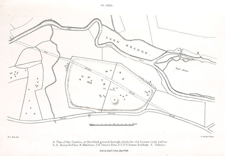
Plan of Durobrivae by Edmund Artis, showing the lines of the ramparts and Ermine Street running through the town. He also shows buildings in red and a large circular feature that he marks as ‘E’, which in other references he calls a ‘tumulus’.
Town Wall and Gateways
The major Roman buildings and the urban sprawl of the organic, unplanned development of the town were walled at some stage in their history. It may be that some of the large public buildings are contemporary or even later than the defensive circuit. Edmund Artis appears to have carried out some excavation over the lines of the defences of the town in the 1800s, but our main source of information comes from aerial photography and the two sections through the western wall line cut in 1956 by Greenfield. The aerial photographs show the entire circuit of the defences, which are especially clear on the northern, western and southern sides but masked by an ancient tree line on the side that borders the river Nene.
Greenfield’s work revealed that the stone wall on this western side rested on a drystone foundation backed by a clay ramp which was constructed in the 2nd century. It is unclear if the wall was inserted into the front face of an earlier earthen rampart, or the wall and bank should be seen as contemporary. Behind this wall and ramp and running parallel to them he found evidence for a road which had 6 distinct phases in its construction. The rampart/walls may in fact have separated the intramural area from suburbs which already existed when the boundary was built. For example, on the western and southern sides of the circuit it looks as if settlement along both Ermine Street and the road heading towards Irchester could have been truncated by the line of the rampart/wall.
It is possible to detect what appear to be towers projecting from the walls on some aerial photographs, which could be later additions added perhaps in the 4th century. The road, which follows the entire inner circuit of the town wall, must clearly imply some form of planning meant to unify the communications within the town and presumably improve the defensive capabilities of the wall should the town have come under attack.
There appear to be at least 4 or 5 gateways into the town, of which those on the northern and southern side town were probably the most substantial (and possibly the earliest). Nothing is known of the Durobrivean gates, although air photographs suggest that the southern (London) gate along Ermine Street was set at right angles to the main wall line, in a dog-leg fashion, perhaps designed to give greater defensive strength to the entrance. This off-set gate design is also probable at the western (Irchester) gate where the wall is also clearly staggered. A fourth gate is likely at a point on the north-western side of the town facing the fort area.
A massive ditch outside the wall line on the western side of the town appears to skirt around the southern and northern defences. On aerial photographs this always shows as a broad green strip due to the moisture still contained within the underlying buried ditch. Greenfield’s section over this ditch, which he calculated to be 10 metres wide, filled with water when he reached a depth of about one and a half metres and we know nothing of the depth of the town ditch, other than to say that it was probably deep and was certainly wet.
Whether the defences were maintained into the late 4th and early 5th centuries is unknown; all we can be certain of is that the wall, which was seen in the Greenfield excavations of 1956, was substantially robbed and at present stands to a height of just over a metre. Some of the gates may have been blocked in the later Roman period as an additional tightening of the defences against attack - this is a feature of other town defences within the province at this period.
To provide new and reliable information with which to better understand Durobrivae and its surroundings, the NVAT recently initiated an ambitious programme of investigation including geophysical surveys and excavation. Partners involved with this programme include Historic England, Durham University, Cardiff University and The British Museum.
